
A Neutral Side of History
Archaeology provides us with a neutral side to history. It gives us a glimpse into an untold or undocumented part of history at a certain location. There are many historic sites in Ohio that are well known for their post-European settlement importance. Many of these sites, in addition, have a rich history prior to European contact. One of these sites is the Rankin House in Ripley, Ohio.
The Rankin House
Reverend John Rankin owned the property from 1828-1865. Until 1863, the family and their neighbors sheltered over 2,000 slaves, sometimes up to 12 people at a time. The question at hand at the beginning of the investigation is, where would that many people hide without anyone noticing? From archival evidence, as well as interviews, we know that what stands today isn’t what stood before. We know that in the 1940s, the Ohio Historical Society [OHS] did extensive renovations to the site. Alterations included the demolition of a brick kitchen, alteration of two barns, the construction of an addition to the east elevation, and demolition of multiple outbuildings and fences. While some of the buildings can be seen from aerial photos around that time, buildings which were demolished before that were still a mystery. One of the mystery buildings, which was a focal point during this investigation, has been referred to as The Rankin Barn. Rev. Rankin’s grandson stated that freedom-seekers were hidden in a cellar under a barn 100 feet west of the house. Decades later, however, he claims that the building used to house fugitive slaves in an ample cellar was located 150 feet northwest of the house.
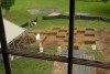
Excavation units on the Rankin House yard. Credit: Terry Prather / The Ledger Independent.
Pieces of the Puzzle
While it’s something which may seem obvious, let’s remember that during the Rankin-era occupation, trash collection didn’t occur. We can learn a lot about consumerism and daily life patterns through the material culture left behind. Additionally, more can be learned about both those seeking freedom, as well as those helping hide people during the Underground Railroad era. With this in mind, locating and research what was found in the previous kitchen, the cistern, and privy all would contribute greatly to better interpretation of the site.
Knowing the area described where the barn and kitchen could be located seems to beg the question, well, why not just look there? Shovel tests were performed and units were excavated throughout the site. However, due to the extensive remodeling of the site in the 1940s, the data remains inconclusive. The mixture of layers allowed modern day plastic to sit next to historic ceramic pieces. The remodeling also meant bulldozing many structures, so the layout of the buildings is also no longer available, as infill has occurred through much of the site.
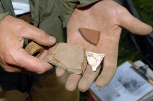
A variety of ceramics found by archaeologists. Credit: Terry Prather / The Ledger Independent.
Geophysical Testing
Another important outcome from the research at the site came through “ground-truthing”, or the use of equipment like ground penetrating radar to determine whether there are any anomalies in the soil, like larger rocks, a change in soil, or metal. In 2010, a geophysical survey of the site took place. The area most impacted by construction, as well as a focus on the highest and flattest elevations of the site were the areas of focus. Until 1950, a major farm road ran through the site, in a north-west direction. The first area was closest to the house, and known to be most impacted by the site reconstruction. The second area was a curving linear ridge covering approximately 4.5 acres on an east to west sloping slope. The old farm road cut through this area, and a gas pipeline was present. Twenty-seven areas were focused on in this geophysical survey, particularly along the higher portions of the ridge. Far less iron anomalies were found compared to closer to the house, which would indicate less historic-era activity. Yet, there were a number of distinct anomalies, which resemble characteristics of features such as a prehistoric pit. These areas were further investigated; half produced evidence pointing towards prehistoric cultural activity, as indicated by burned earth, charcoal, and dark soil. In conclusion, there appear to be two distinct prehistoric occupations in this area of the site.
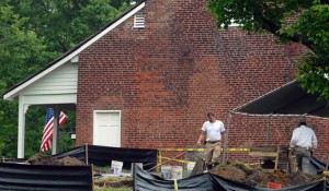
Photo Credit: Terry Prather / The Ledger Independent
While the excavation provided some answers to questions, it also presented an entirely new set of questions and directions to take future research. The location of where Rankin hid freedom seekers, and how that many people would have passed through going unnoticed, are questions which remain unanswered. Having located the privy, cistern, and bottle dump, questions regarding consumer patterns and daily life may be able to be answered with further research. We know that a lot of site disturbance occurred in the 1940s; however there is more to the site than just the Rankin occupation period. With the location of many soil anomalies, areas with burned earth and charcoal, new questions now surface. What was the property used for prior to the Rankin occupation? How long people using the property and how many people were were there? This property continues to be an amazing research and teaching site.
![]()